Helvellyn and Fairfield
This area of fells rises above Ambleside and runs north for about 12 miles to Threlkeld. For most of this distance the main north-south ridge is above 2000 ft high (or 600m approx.), except at Grisedale Tarn which conveniently divides the area into two groups; Helvellyn in the north, Fairfield in the south. Wainwright lists 35 fells in total for the Eastern Fells.
Helvellyn
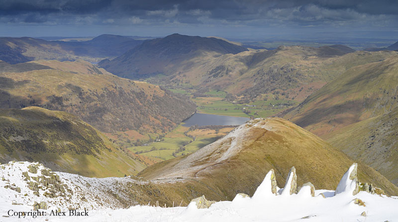
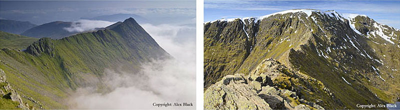
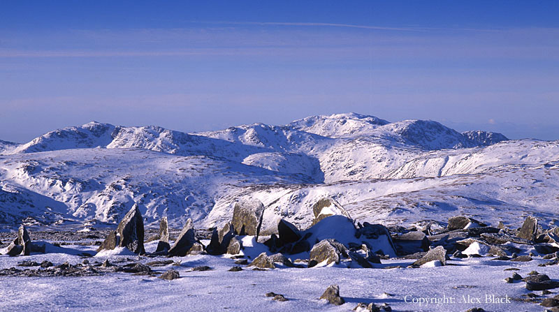
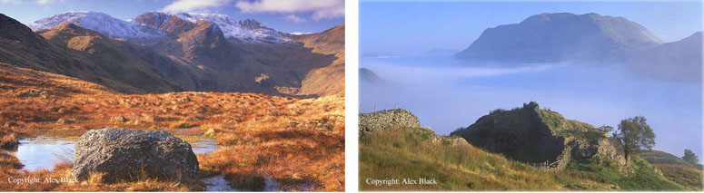
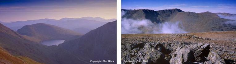
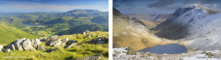
As England’s third highest mountain, Helvellyn (950m) is the highest point in the Eastern Fells, and for mountain scenery it is the highlight in almost every way. On its western side, Helvellyn rises steeply above Thirlmere in an impressive jumble of rock and scree; the easier routes of ascent are on this side, with the main starting points being Wythburn and Swirls. However it is the eastern side of the fell which has the best of the mountain scenery. Tucked in below the cliffs here, almost 200m below the summit is the mountain lake of Red Tarn.

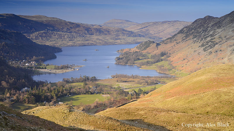
Red Tarn is certainly worth a visit in its own right, walking up from Glenridding, but it is the two knife-like ridges of Striding Edge and Swirral Edge which are the most dramatic features of the fell. Striding Edge is the more famous of the two, but both are dangerous places for inexperienced walkers, especially in winter conditions. For many, the challenge is the attraction, making Helvellyn one of the most-climbed mountains in Britain (but also an accident black-spot). The classic route from the east starts at Glenridding near the head of Ullswater; from here there is a choice of routes ascending to Striding Edge, my favourite is the route which crosses over to Grisedale by Lanty’s Tarn and climbs the fellside on a path with a steady gradient.
Once Striding Edge has been negotiated, a rough ascent brings you onto Helvellyn, then cross the summit, to descend to Red Tarn by Swirral Edge, returning to Glenridding by Red Tarn Beck and Glenridding Beck. The view from Helvellyn’s summit is arguably the best in the Lake District, taking in almost all of the high fells as well as many of the lakes; the views down over the two Edges to Ullswater is probably the best bit of the whole panorama.

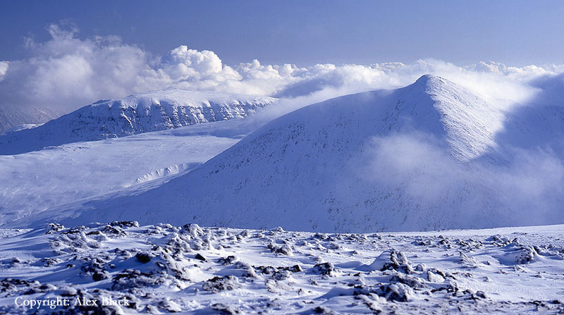
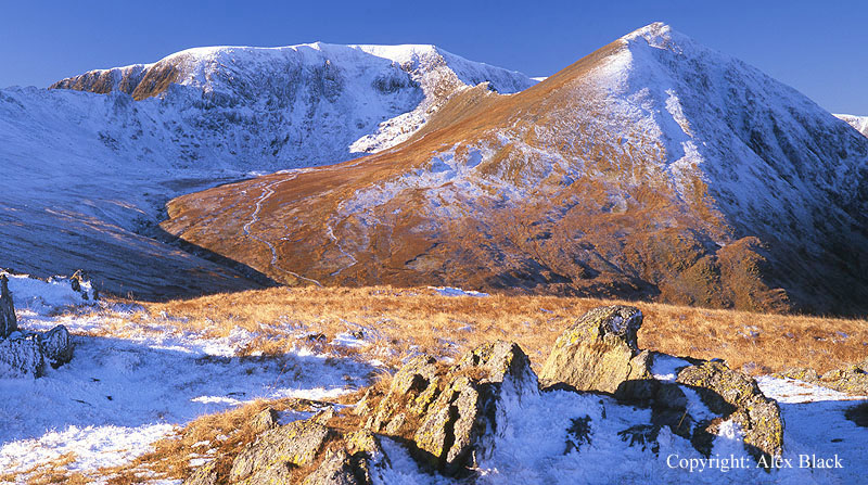
Including Helvellyn, there are 17 fells in the group north of Grisedale Tarn, and arguably the finest summit in this area is Catstye Cam (890m). This fell is perhaps little more than the end of Swirral Edge, but three ridges rise here, almost geometrically, to its neat rocky top. Although less than a mile from Helvellyn, Catstye Cam is not completely overshadowed by the higher fell, and has good views in most directions, particularly looking back along Swirral Edge and down onto Red Tarn.

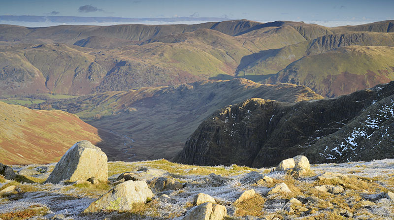
Next in height to Helvellyn is Nethermost Pike (891m) which is the fell immediately south of Helvellyn, on the main spine of this group of fells. The summit is disappointingly wide and flat but like the higher fell, the best of the rocky scenery is on the eastern side where crags fall steeply down to the deep valley of Grisedale.
Just south of Nethermost Pike is Dollywaggon Pike (858m) which has a more interesting summit, with the cairn perched on the top of a narrow ridge dropping down into Grisedale; here too, it is the eastern side of the fell which has the best of the craggy scenery.
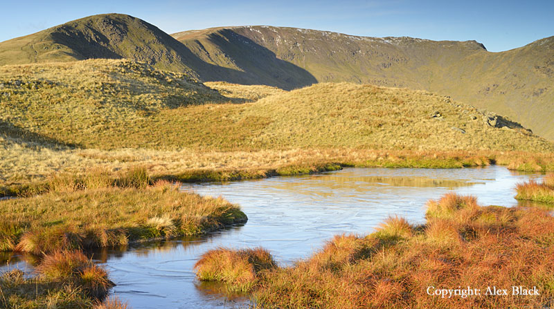
North of Helvellyn there are a further six fells on the main ridge. The fells here are less rocky than on Helvellyn itself, but the wide, grassy ridge gives some excellent walking, much quieter than Helvellyn, and as these are still high fells there are still excellent views here.
My favourites here are Raise (883m) and Great Dodd (857m); Raise is famously the home of the only ski club in the Lake District.
Just north of Raise the ridge is crossed by Sticks Pass, an ancient track connecting Legburthwite on the Thirlmere side to Glenridding on the Ullswater side of the range.

Starting at Legburthwaite, this is one of my favourite routes up onto the Helvellyn range; although a longer route for Helvellyn, it is an easier route with more interesting views. At its northern end, the main spine of the Helvellyn range comes to a dramatic end at Clough Head (726m) where crags descend steeply to the quarries at Threlkeld.

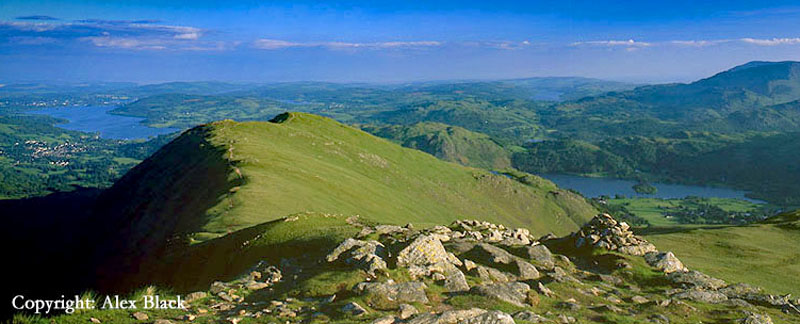
East of the main ridge there are lower fells running down to Ullswater and Glenridding. The best of these are Sheffield Pike (675m) and Birkhouse Moor (718m).
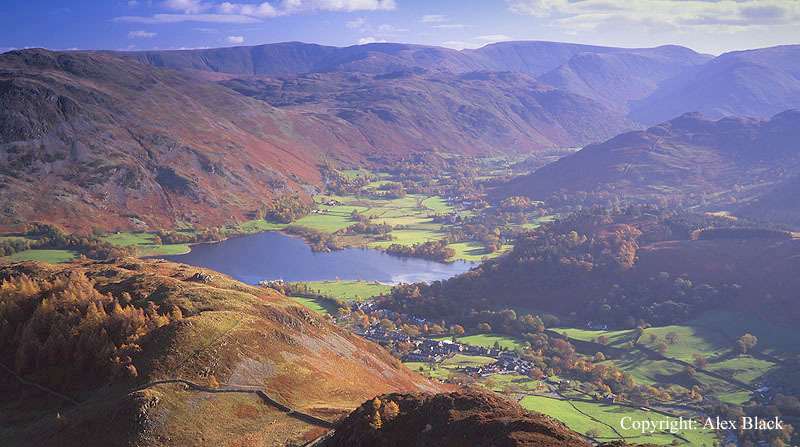
Sheffield Pike can be climbed directly from Glenridding, going over the rocky tor of Heron Pike at its eastern end; it is from here you get the best views, particularly of Ullswater, taking in almost the whole lake. This eastern end of the summit is a lovely place particularly in late summer when the heather is out.
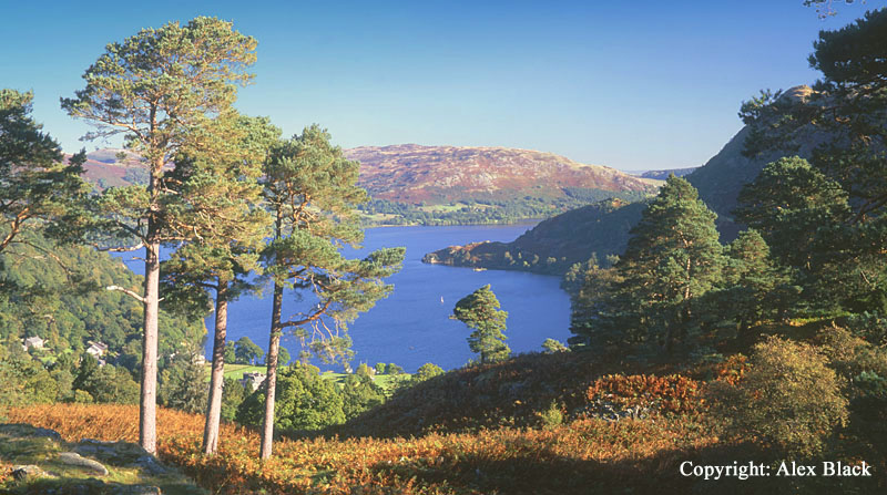
Although Birkhouse Moor also has good views of Ullswater, the summit is much less interesting as it is crossed by a large wall and the main path to Striding Edge. Few walkers seem to stop here, but the view of Helvellyn and Catstye Cam is quite impressive. On the lower slopes of Birkhouse Moor is one place worth turning aside for; just above Glenridding is the little rocky hill of Keldas, where there is a lovely view of Ullswater framed by pine trees.
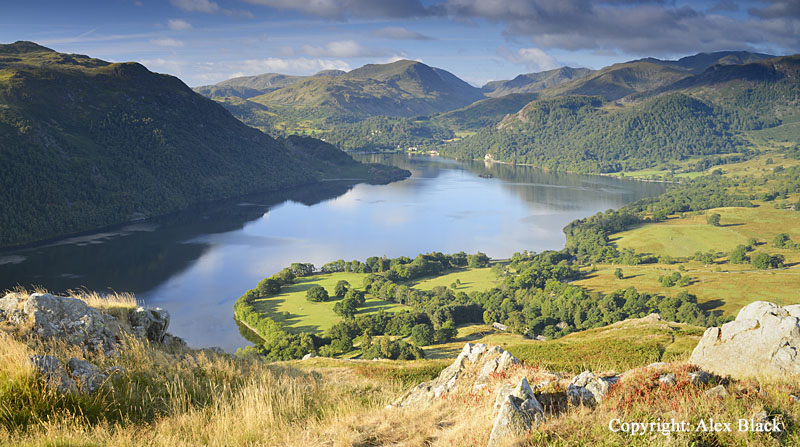
Wainwright also included three lower fells to the north-east of Helvellyn near Dockray. Most famous of these is Gowbarrow Fell (481m), which can be climbed from Lakeland’s most famous waterfall, Aira Force. It is an un-written rule of the Lake District that the lower fells often have the most beautiful views, and the view towards the head of Ullswater from the southern end of Gowbarrow Fell is a perfect example. The summit of the fell is about 1km north across undulating moorland; there is just a limited view of the eastern end of Ullswater from here although there are still good views of the fells.
Nearby is Great Mell Fell (537m), a distinctive dome-shaped hill, and a landmark for travellers on the A66 near Troutbeck. There is a lot of very wet ground here, but there is now a good path to the summit from near Brownrigg Farm at the south-eastern side of the fell. The summit has one of the finest views of Blencathra, and the wind-blown larch trees seen on the way up are an unusual feature.

The third fell here is Little Mell Fell (505m) which has a similar dome shape to its neighbour, Great Mell Fell.
This is one of the easiest Wainwrights to “bag”; the ascent being a short walk from The Hause to the south. From the summit there is a view of Ullswater and the northern High Street Fells, but being tucked in between its two neighbours, they have unfortunately robbed it of the best of the views.
Fairfield
South and east of Grisedale Tarn rises a group of 18 fells, the highest of which is Fairfield (873m). Fairfield ranks as Lakeland’s 13th highest fell, so good views are guaranteed; almost all of Lakeland’s high fells can be seen except for the Northern Fells (Skiddaw and Blencathra) which are hidden behind Helvellyn.
On clear days, the view east to the Pennines and the hills of the Yorkshire Dales is impressive, but for me, Fairfield’s height and position give it a unique vantage point over the lakes of south Lakeland. Windermere, Esthwaite Water and Coniston Water lie spread out below, stretching out to Morcambe Bay, with glimpses of smaller lakes too; Blelham Tarn, Elterwater and Easdale Tarn. Fairfield’s summit is a sprawling, stony plateau, so a tour around the edges is needed to get the best of these views, and of Fairfield’s crags which are below its northern and eastern edges.

Fairfield stands at the highest point in a system of ridges, and most walkers arrive at its summit over some of the lower fells in the group. The most famous of these routes is the “Fairfield Horseshoe”. This can be started from Ambleside or Rydal, and including Fairfield, this takes in eight fells in all, with the total distance being about 16km (10 miles). This route is also sometimes called the Rydal Horseshoe as it makes a circuit of the valley of Rydal Beck.
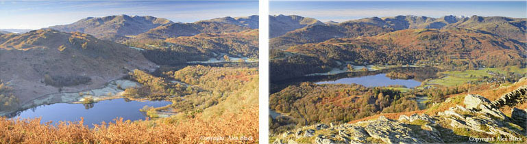
Starting from Rydal in a clockwise direction, the first fell is Nab Scar (440m approx.) which has good views of Rydal Water on the way up, and then of Grasmere from near the summit cairn. The views start to open up more at Heron Pike (612m) which is just above the 2000ft mark.
A grassy ridge then stretches along then up onto Great Rigg (766m): the views south from here are as good as those from Fairfield, taking in all the main lakes in the south Lakes, as well as Grasmere and Alcock Tarn.
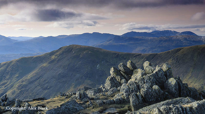
After Fairfield the route bears east around the head of Rydal Beck, then turns south onto Hart Crag (822m); for those who like to walk on rock, this is the best section of the walk, and probably the best summit on the Horseshoe.
After Hart Crag, a wall appears that can be followed onto the wide, flat top of Dove Crag (792m). The crag the fell takes its name from is about 200m north of the cairn, overlooking Patterdale and Dovedale; this is arguable the best viewpoint on the fell, and should be visited first by bearing left before heading to the summit cairn. From the summit of Dove Crag, the wall continues on to High Pike (656m) which has good views south and down the ridge to Low Pike (508m), which is the last summit on the Horseshoe.
The other horseshoe route possible for Fairfield starts from Patterdale and visits six fells including Fairfield. This is the Deepdale Horseshoe which is slightly shorter than the other Horseshoe just mentioned, but with rougher ups and downs. Starting from Bridgend, the first fell on this route is the gently curving ridge of Hartsop-above-How (580m); although Ullswater is hidden, there are lovely views here of the hills around Patterdale and Hartsop. The ridge continues on to Hart Crag (822m) where the last 300m of ascent is very steep and rough. On the summit of Hart Crag turn right and join the main path onto Fairfield (873m).
From the summit of Fairfield there is a steep, rough descent over Cofa Pike to Deepdale Hause; this is the trickiest section of the walk and care must be taken especially in winter; please consult a detailed guidebook such as Wainwright for the best advice on tackling this route. From Deepdale Hause (685m approx.) an easier path continues on up to St Sunday Crag (841m). Although this route does not really show St Sunday Crag at its best, this is arguably the finest fell of the Fairfield group, and is only second in height here to Fairfield; the north-western face above Grisedale is particularly impressive.

There are good views from the summit in almost every direction but the best view is of Ullswater from the north-east ridge. The main path goes down this ridge.

After descending this ridge (approx. 240m of descent) to arrive a slight dip, a clear path bears left which is the direct route down to Patterdale and can be taken if necessary. However, to continue on the Horseshoe route bear right onto Birks (622m). The summit here is an almost featureless, grassy ridge but there are good views of the surrounding fells. To complete this Horseshoe, descend east to Trough Head, then follow a grassy ridge onto Arnison Crag (433m), the last fell in the horseshoe. There are rocky summits here and lovely views of the head of Ullswater, and the fells around Patterdale and Hartsop. Unfortunately the south side of the fell is too steep to allow a direct descent to Bridgend, so descend north to Patterdale then follow the road back south to the car.
There are two other fells in the Fairfield group worth mentioning. The first is Seat Sandal (736m) which is west of Fairfield, and rises over Dunmail Raise (the highest point on the A591 north of Grasmere). Seat Sandal is the linchpin of the Eastern Fells, connecting Fairfield to the main ridge of Helvellyn, and sits at the head of the Grisedale valley which runs north-east towards Ullswater It is easily climbed from Dunmail Raise via Raise Beck, and can include a visit to Grisedale Tarn. There is a wonderful view over Grasmere from the summit, and the view north-east over Grisedale Tarn towards Ullswater and St Sunday Crag is an impressive mountain scene.
The second fell is Red Screes (776m) which rises as a long ridge north of Ambleside, and overlooks the Kirkstone Pass on its eastern side. The quickest route to the summit is by a short, steep, rough ascent from the Kirkstone Pass, but the fell can be climbed by a more leisurely gradient from Ambleside, approx. 5km (3 miles) each way. If needed, an alternative route back to Ambleside, would be via Scandale, which is a wild valley west of Red Screes, separating it from the eastern leg of the Fairfield Horseshoe. For this route, bear west from the summit to join a wall after about 600m, and follow this downhill bearing north-west to arrive at Scandale Pass after approximately 1km. The fell which rises just north of the pass is another Wainwright summit, Little Hart Crag (637m), and can easily be visited from here. Otherwise, bear left at the top of the pass and follow a good path back down to Ambleside.