High Raise, Ullscarf and the Langdale Pikes
This area of fells rises north-west of Ambleside between the valleys of Great Langdale and Rydal/Grasmere; the high ground then continues north between Borrowdale in the west and Thirlmere in the east, finally falling away at the outskirts of Keswick. Although the fells here are lower than those in other groups, this is the central spine of the Lakeland Fells, and includes many favourite walks. Wainwright lists 27 fells in the group.
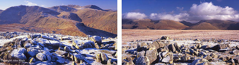
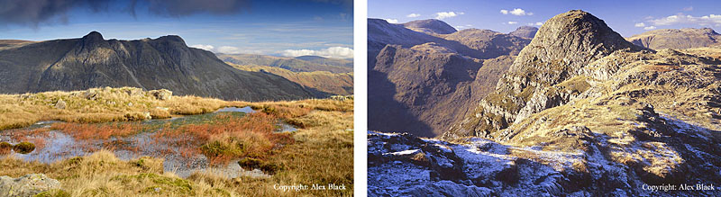
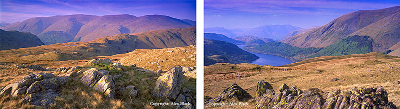
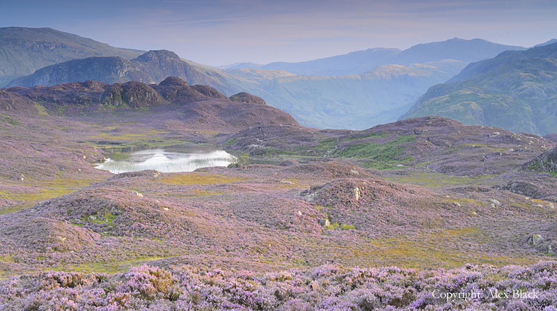
The highest fell in the group is High Raise (762m) which stands hidden away between Langdale and Borrowdale, at the top of a system of ridges. High Raise has a wide flat top which is difficult to spot in views, but it has often been seen as the centre point of the Lakeland Fells, making this is an excellent place to view the higher fells on all sides.

At the south-eastern end of High Raise’s summit is the prominent rocky tor of Sergeant Man (740m approx.) which Wainwright treats as a separate fell. Sergeant Man stands at the top of a long ridge which stretches all the way down to Ambleside via Silver How and Loughrigg Fell; and this is a great viewpoint for the fells and valleys of the south Lakes.
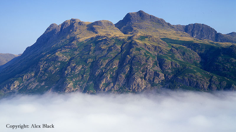
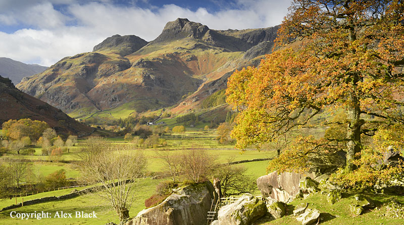
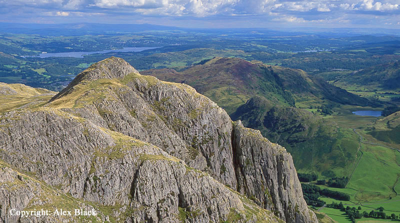
High Raise and Sergeant Man might be the highest points of the Central Fells, but the Langdale Pikes are the most famous by far, their craggy outlines draw the eye in many views, but especially from Windermere near Lowwood Bay. The Langdale Pikes are in fact a cluster of 5 fells, in order of height they are: Harrison Stickle (736m), Thunacar Knott (723m), Pike of Stickle (709m), Pavey Ark (700m approx.) and Loft Crag (675m approx.).
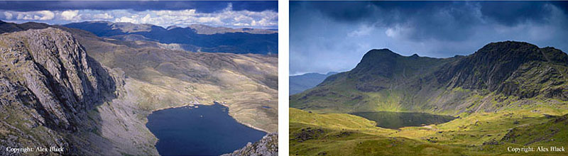
Starting with the highest, Harrison Stickle; with its fine rocky summit, this is the most prominent of the Langdale Pikes, with almost aerial views down over Great Langdale. The best of the crags are around the south side of the Langdale Pikes and it will come as a bit of a disappointment to find that there is rocky moorland to the north that connects all of The Pikes with High Raise. The Wainwright summit here is Thunacar Knott which is less than 1km north of Harrison Stickle. There are no dramatic crags here just gentle, grassy moorland which rises to a pair of flatish, rocky summits separated by a small tarn.
Next in height is Pike of Stickle, or Pike ‘O Stickle as Wainwright has it. This is properly the second of the Langdale Pikes, rising steeply from the head of Great Langdale with a distinctive dome-shaped summit. Pike of Stickle is famous to archaeologists as being a source of Neolithic stone axes quarried here as much as 4000 years ago, which have been found across Great Britain.
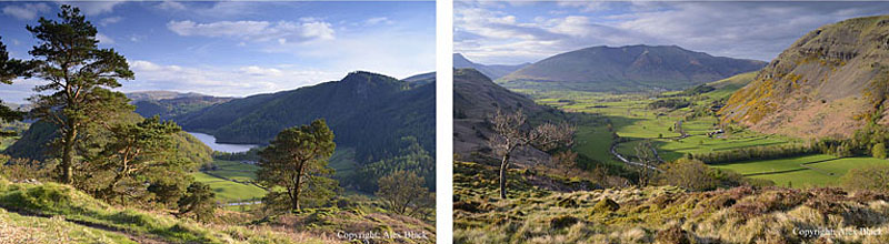
Pavey Ark is next in height; in most views of The Pikes from the south, Pavey Ark is the large crag to right of Harrison Stickle. Below the crag is Stickle Tarn, a dramatic location, worth a visit on its own. The last of The Langdale Pikes is Loft Crag which sits between Harrison Stickle and Pike Of Stickle. This is a lovely little summit, with some of the best views from The Pikes.
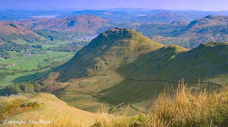
The ridge down to Ambleside from Sergeant Man includes 3 Wainwright fells, some of which have the most popular walks in the Lakes. The most southerly of these is Loughrigg Fell (335m) which rises immediately to the west of Ambleside. This low fell is perhaps the best positioned of any fell in the Lake District, being surrounded by lakes: Windermere, Rydal Water, Grasmere and Elterwater; it even has its own tarn on the Langdale side, Loughrigg Tarn.
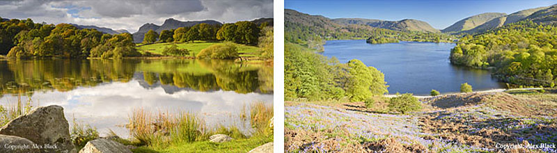
Arguably the best walk here is a circuit of the fell, to get the best views; Loughrigg Terrace has one of the best views of Grasmere, and Todd Crag above Ambleside has an excellent view of Windermere. Loughrigg’s summit is a little rocky tor topped by a trig point; there is a great panoramic view of the surrounding fells, but being set back from the edges of the fell, none of the lakes are clearly seen from here.
The next fell on the ridge leading up to High Raise is Silver How (395m). Silver How rises steeply above the west side of Grasmere with a prominent summit, and from here there is a wonderful bird’s-eye view of Grasmere with Rydal Water beyond.

On its Langdale side, Silver How rises steeply with many little crags, but between these two aspects is a wide area of undulating moorland, tricky to navigate in mist, but not without interest. About 1km west of the summit is a small group of tarns, near the rocky mound of Lang How; this is one of the best viewpoints for the head of Great Langdale.
North-west of Lang How the ridge continues over Castle How to Blea Rigg (530m). Castle How is a confusing place to navigate, with lots of little summits, but at Blea Rigg the crest of the ridge narrows with crags falling away to Easdale Tarn on the north-eastern side. Looking west there is a good view of Stickle Tarn and the Langdale Pikes. Continuing north-west this ridge climbs up to Sergeant Man and High Raise.
Besides the ridge the ridge down to Blea Rigg, Sergeant Man sends out another ridge, this one heads east over some very wild terrain, which after almost 2km it finally narrows and rises to the summit of Tarn Crag (549m). The fell’s distinctive domed top is visible from Grasmere, but is best seen from Easdale Tarn, from where it gets its name. The ridge of Tarn Crag continues south-east from the summit, dividing Easdale from Far Easdale; arguably the best crag on Tarn Crag is Deer Bields Crag which is on the Far Easdale side.

North of Grasmere is the little rocky fell of Helm Crag (405m). This is a distinctive little fell in many views, but in the Grasmere skyline as it has a wonderful mountain shape, particularly when seen from the lake. In truth, Helm Crag stands at the end of a ridge, but the summit does not disappoint; the summit is a ridge in itself, being about 200m long with distinctive crags at both ends the ends.

These crags have been given names over the years; the crag at the south end is The Lion and The Lamb, and at the north end it is The Old Woman and the Organ, or The Howitzer.
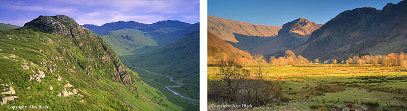
From Helm Crag it is possible to do a short horseshoe walk; the ridge north of Helm Crag is an enjoyable walk, a twisting path among little rocky knolls. After a steep descent to Bracken Hause, the path goes over Gibson Knott (420m approx.) first then on to Calf Crag (537m) which stands at the head of the Far Easdale and Greenburn valleys, and overlooks the Wythburn valley to the north. From Calf Crag, bear right around the head of Greenburn onto Steel Fell (553m) which is the highest point on the walk.
Steel Fell is in a good position in the middle of the Lake District as it stands on the west side Dunmail Raise. Although Steel Fell is not really high-enough to take advantage of its position, there are good views both north and south. To return to Grasmere take Steel Fell’s south ridge, where there are good views of Grasmere ahead.
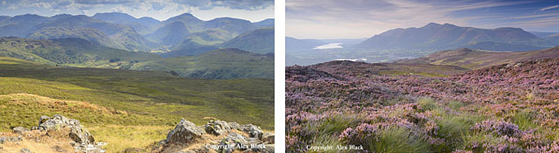
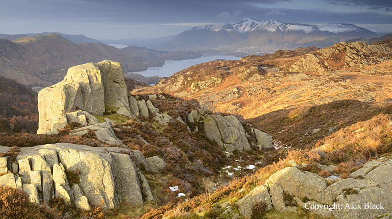
North of High Raise the main ridge of the Central Fells continues over Greenup Edge to Ullscarf (726m). Ullscarf is the highest point in the group of fells between Thirlmere and Borrowdale, standing on the main ridge running north almost to Keswick. Ullscarf itself is almost 5km (3 miles) wide and as the best of the crags are to be found around its edges, the upper slopes therefore tend to be gentle and rather boggy.
Luckily, the summit is relatively dry being a grassy little ridge, crossed by the remains of a fence. For me this is the central point of the Lakeland Fells, with a comprehensive panorama of higher fells in every direction, except the south-east; the only real omission is the Far Eastern Fells which are hidden by Helvellyn and Fairfield.
North of Ullscarf the highest ground follows the watershed between Thirlmere and the Derwent. The next summit, High Tove (515m) is some 4km (2.5 miles) north of Ullscarf; this is not a ridge walk as you would normally expect in the Lake District, being extremely wet underfoot in many places. Its one redeeming feature is that the fells north from here are some of the best places to see heather in the Lakes, so visiting in late July to August is recommended (but pray for a dry spell).
The next fell on the ridge is High Seat (608m), which is second in height to Ullscarf of the fells north of Greenup Edge. This is a neater, rockier summit here than on Ullscarf, and the views are somehow more attractive, but the summit is virtually surrounded by bog and heather. Access to the summit has been improved in recent years by the National Trust (the landowners here) by laying a good path from above Ashness Bridge; this route crosses the west flank of High Seat where the heather is spectacular in late summer.
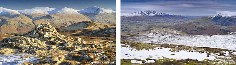
Bleaberry Fell (590m) is the next fell north of High Seat, and the last of high fells on Lakeland’s Central ridge. As with High Seat, access has recently been improved by the National Trust; the path from the top of Cat Gill has been upgraded making it much easier to cross several bad areas of bog.
From this approach, the summit appears to be a rocky dome, and this is the only steep bit of the walk on this route. On the summit, there are a couple of large cairns, and this is probably the best viewpoint on the ridge, having the advantage of seeing more of the lakes and valleys.

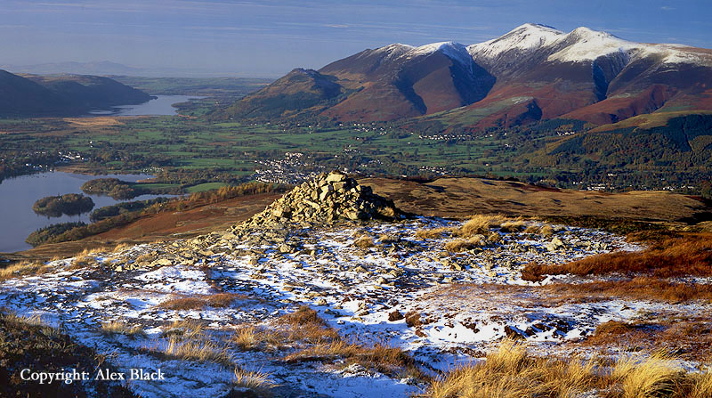
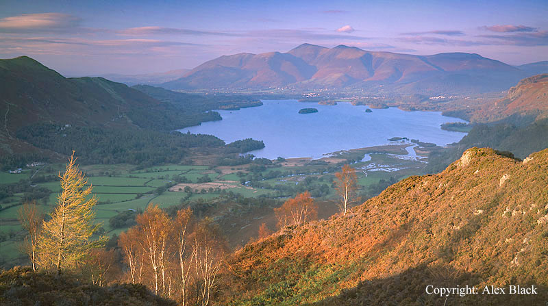
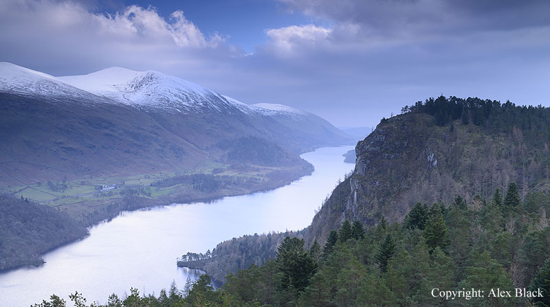
The best views in this area tends to be from the lower fells; one of the most popular is Walla Crag (379m) which rises as a wooded crag just south-east of Keswick, and is a popular walk from there. The summit has an attractive mixture of trees, heather and rocks, and there is an excellent birds-eye view of Derwent Water. The popular route from Keswick crosses the summit then descends to Ashness Bridge and returns by the lakeshore path.
Standing in an excellent position between Borrowdale and the head of Derwent Water, is Grange Fell (410m approx.). This fell covers a substantial area and in spite of its position it is relatively little-walked, perhaps because of its rambling, boggy summit. In fact there are 3 distinct summits here: the point usually taken as the top is Brund Fell (410m approx.) which is roughly central to the fell as a whole. The views of the fells from here are good for such a modest altitude, although not the best views Grange Fell has to offer; the interest here is the summit itself with its rocky tops which would add much to many higher fells.
Grange Fell is home to one of my favourite place names in the Lake District: Jopplety How, which is a rocky tor north-east of the summit. There is heather here too but also boggy areas; anyone thinking of investigating Grange Fell’s second summit, Ether Knott (also 410m approx.) should be warned that route-finding is not easy; on what appears to be a relatively short walk north-east from Brund Fell, the 1km (0.65 miles) of ground covered is boggy and confusing. Ether Knott is perhaps understandably the least visited of Grange Fell’s 3 summits, and there is almost no sign of any well-used paths here. Besides being difficult to get to, the views are no better than those from Brund Fell except for peeping down into the pretty valley of Watendlath.

The summit itself is a little rocky rise, standing on its own little ridge. Walkers arriving here from Brund Fell will be relieved to find that Ether Knott is mostly grassy with some heather too, but much drier than Brund Fell. Ether Knott’s ridge runs north, running parallel to Watendalth Beck towards Lodore; the north end of this ridge at Brown Dodd (just 500m from Ether Knott) has a wonderful but little-known view of Derwent Water seen over the cliffs of Lodore.

In theory there should be a simple way up to Brown Dodd and Ether Knott from above High Lodore, but the overgrown, pathless woods on Comb Crags makes this very unappealing.
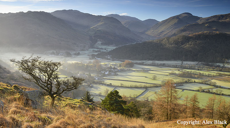
Grange Fell’s third summit is King’s How (392m), which is the lowest and most westerly of the three on Grange Fell, but arguably has the best views. Between Borrowdale and Derwent Water the valley narrows to what used to be known as The Jaws Of Borrowdale (a name now missing from maps); the western side of The Jaws being the popular summit of Castle Crag (covered in Wainwright’s North Western Fells), but it is Grange Fell and King’s How in particular which form the eastern side of the gorge. King’s How has similar views to Castle Crag, both fells have good views looking north to Derwent Water and Skiddaw, and south into Borrowdale, but I have always felt that the views from King’s How are that little bit better. My best recommendation for a walk here: start at Rosthwaite in Borrowdale and take the good path heading east over Puddingstone Bank to Watendalth. Watendlath is not to be missed, an idyllic hamlet tucked away in the fells, with the farmhouse serving tea, coffee and cake on most days Easter to October.
From Watendlath take Wainwright’s route to Brund Fell, then follow his ridge route west then north-west onto King’s How. The best route back to Rosthwaite with the best views is to return towards Brund Fell on the same path, but continue straight on where the path forks off to the summit. The best views of Borrowdale are from this next 200m as the path descends towards Frith Wood. The path then climbs again to re-join the Puddingstone Bank track; turn right for Rosthwaite.
South of Grange Fell is another little rocky, heathery fell: Great Crag (440m approx.). This is easily reached from Rosthwaite, also using the Puddingstone Bank route, but turning right at the top of the path. However, most walkers coming this way do not seem to be heading for the summit, instead it is for Dock Tarn, which is less than 1km south-east of the summit. The heather here is really impressive in late July to early August.
A little further south of Great Crag and almost hidden from view in the Stonethwaite valley are two rocky fells worth mentioning: Sergeant’s Crag (571m) and Eagle Crag (520m approx.). These stand on their own short ridge which comes down from High Raise, and ends dramatically at Eagle Crag. Just 1km south is Sergeant’s Crag which is also has dramatic crags, particularly on the Langstrath flank, and the summit is a great viewpoint for that valley which for many years featured in the title sequence of BBCs Country File.
Perhaps the single most dramatic fell amongst the northern Central Fells, and seen by almost everyone who drives through The Lakes is Raven Crag (461m). This fell rises steeply above the north end of Thirlmere, much of it rising as a sheer rock-face almost directly above the dam. Just north of Raven Crag, and easily reached from there is The Benn (446m). In some ways this is a better viewpoint, having the same wonderful view of Thirlmere and Helvellyn, but including Raven Crag in dramatic profile.
Standing north of Raven Crag, and separated from the other Central Fells by the A591 is High Rigg (357m). This low, rambling fell rises steeply at Legburthwaite near the north end of Thirlmere and stretches north for about 4km (approx. 2.5 miles) almost to the A66. This southern end, Wren Crag, is perhaps the best of the fell, where a rocky path winds through ancient pine-trees; the whole length of the fell, taking in the summit, can be walked from here although the path is a little difficult to follow in places.
The northern third of the fell is wider and spreads west towards Keswick; this is almost a separate fell, Low Rigg, and its northern slopes is home to a tarn of some fame, Tewet Tarn.
