Please note: more photos for this page will be added soon
The Outlying Fells of Lakeland
Wainwright’s original series of seven walking books, the “Pictorial Guide to the Lakeland Fells…” covered the main groups of fells in the centre of the National Park, however this left out many fells around the perimeter of the Lake District. Published 8 years after the “Pictorial Guides…”, Wainwright described “The Outlying Fells…” as being something “in the nature of a mopping-up operation”; perhaps this is correct but it rather understates the challenge of the Outlying Fells. Besides the wide geographical spread, the 56 chapters are in the format of walks rather than a chapter for each fell, and in total, the book covers more than 100 named summits. Many of the walks are short walks to low summits, but some are longer walks to higher fells; the longest walk is over 17km (11 miles) and there are a couple of fells of around 600m high (about 2000 ft). But on the plus-side, most of the walks are across the southern half of the National Park.
I confess, I have not done all the Outlying Fells but the notes here cover the ones I have visited, and like the other pages in this section, the idea is to highlight the best views for photographers. I have of course followed the order used by Wainwright, working clockwise around the area; as a resident of Kendal, Wainwright starts the book in the south-east, with a fell which was almost on his doorstep: Scout Scar.
Scout Scar
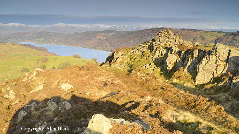
Scout Scar is a mile-long limestone escarpment just west of Kendal, overlooking the Lyth Valley on its western side. The summit has a height of just 229m (764ft) which is much lower than any of the fells Wainwright covered in his Pictorial Guides, but typical of many of the Outlying Fells. There are outcrops of limestone, rather than large stretches of limestone pavement, but limestone is almost always nice to walk on. For Scout Scar the highlight is the view; between west and north-east there is a distant panorama of the Lakeland Fells, and running around the eastern horizon are many familiar hills on the Pennines. This extensive view is celebrated by a distinctive shelter on the summit; its domed top has earned it the affectionate nick-name “the Mushroom”.
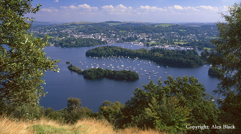
Orrest Head
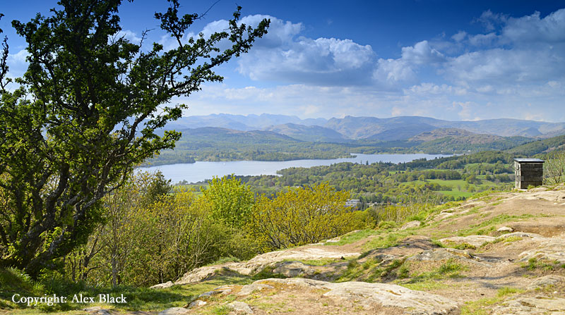
This is one of the most famous hills covered in the Outlying Fells. The summit (238m) is a short walk from Windermere (town) which can often be done from the railway station while waiting for bus or train connections; the view is therefore fondly remembered as a welcome or farewell to Lakeland’s glorious scenery. This was certainly Wainwright’s experience on his first visit from his native Blackburn. Most of Lake Windermere can be seen, overlooked by many of the fells across South Lakeland; the Coniston Fells, and the fells around Langdale, Grasmere, Ambleside and Troutbeck. But best of all, the distinctive Langdale Pike are seen neatly positioned above the head of the lake.
Brant Fell

Brant Fell stands a short distance from Bowness, and, like Orrest Head, is of modest height, just 129m. However, the short ascent from the busy streets of Bowness makes for an easy and delightful walk from the town. The top of the fell is a mixture of open, grassy hillside and low crags, giving wonderful views over Windermere and the fells of the south Lakes.
Whitbarrow
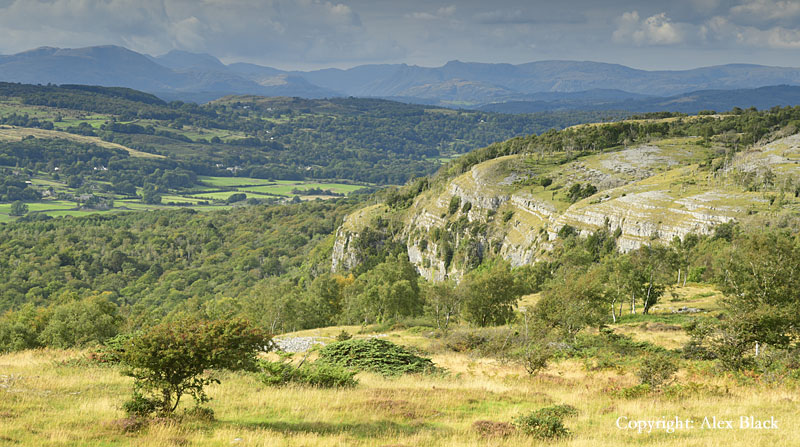
Whitbarrow lies out on the south-eastern edge of the National Park, where its southern corner overlooks the A590 near Witherslack. The fell is a limestone escarpment similar to Scout Scar; on its eastern side, wooded, limestone slopes rise gently from the Lyth Valley, but on its western side the fell has some impressive cliffs. The fell is about 5.5km long on this western side, with the main path running along above the cliffs; luckily there is no woodland along this edge of the fell, giving open views, and the few trees that are here add much to the interest of the walk.
The summit is named Lord’s Seat (215m), and is about half-way along this western edge; although the high Lakeland Fells are rather distant, there are good views in most directions, including south to Morcambe Bay.
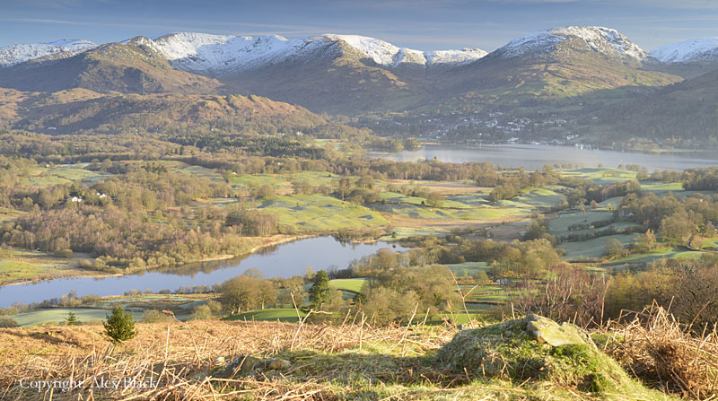
Gummer’s How
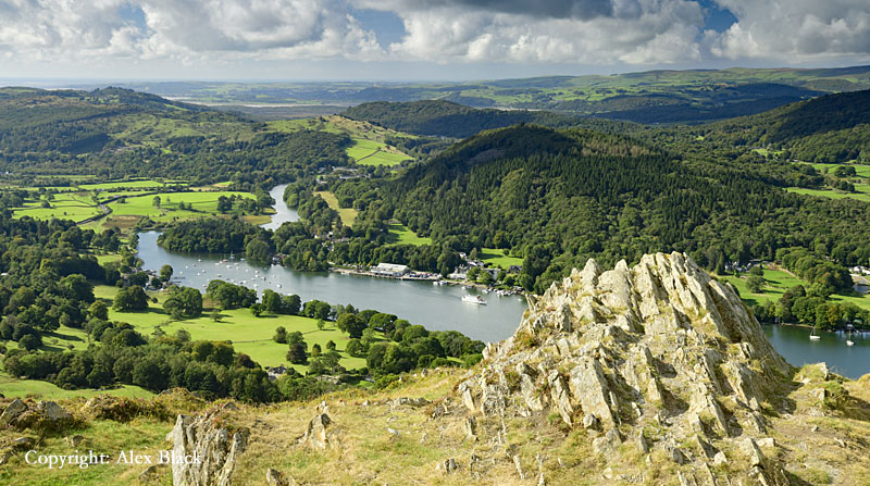
Gummer’s How has a prominent position above the foot of Windermere, and is well-known as a view-point for the lake. At 321m, the fell has a reasonable height, but there is an easy walk to the top from the carparks on the Fell Foot Brow road. There are good views of the higher Lakeland fells to the north and west, but the best bit of the view is actually looking down on Lakeside and the bends in the River Leven.
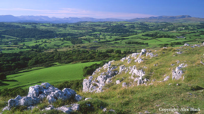
Hampsfell
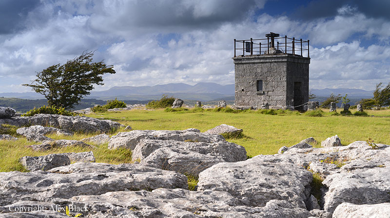
This delightful little hill is on the most southerly edge of the National Park, rising between Cartmel and the seaside town of Grange-over-Sands; its summit is less than 2km from the Grange’s pleasant promenade. Wainwright gives a route of about 5.5km (3.5 miles) starting from and returning to the town centre, but it is also possible to start from the top of Grange Fell Road where there is parking for a few cars. There are many outcrops of limestone across south Cumbria, but this is possibly the nicest: just north of the summit is a substantial area of limestone pavement, although overgrown in places. The summit itself (220m approx.) is crowned by The Hospice, a small, square-ish building, dating back about 150 years, and built of limestone. The interior is open and serves as a shelter in bad weather, and in good weather its roof can be accessed by a narrow, open staircase, and works as a viewing platform. Being so far south, the high fells of Lakeland are a long way off, but it is still lovely panorama; the Coniston Fells and Fairfield are the most prominent in the view, but there is a surprise appearance by Skiddaw, more than 30 miles to the north.
Humphrey Head

About 5km (3 miles) south-west along the coast from Grange-over-Sands is Humphrey Head. This low fell (just 53m high) is a little, limestone headland, pointing out into Morcambe Bay and is the only fell in the book which lies outside the National Park. Wainwright excuses its inclusion by saying it added variety to the book to have a coastal walk; this is true, although the sea can often feel like a long way away on Morcambe Bay. There are some nice views here, mainly across the bay, as the views of the high Lakeland Fells are rather limited. One thing to mention to first time visitors to Morcambe Bay is that the sands are dangerous, and walking on the sands is not recommended.
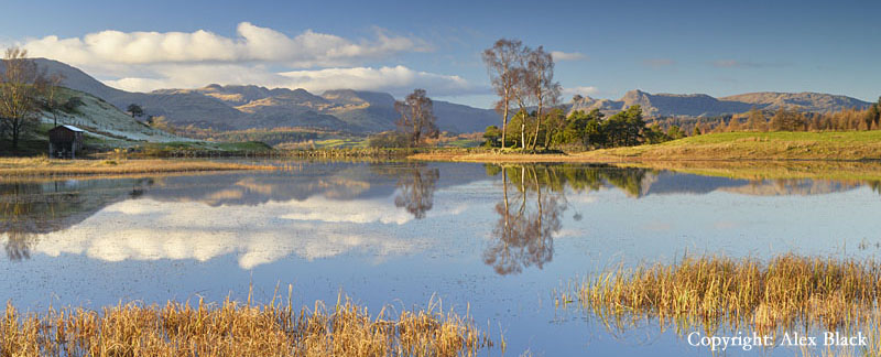
Claife Heights
Claife Heights stands on the western shores of Windermere, rising steeply opposite Bowness, one of the busiest places in The Lakes. The fell stretches for about 3km, north to south, with much of it wooded: the peace and quiet of the woodland is in sharp contrast with the bustle across the lake. There are a couple of places along the top of the hill where the woodland clears to give views over Windermere, but there are gentler slopes to the west where a few tarns can be found with more open views.
Latterbarrow
Latterbarrow is a neat little hill (height 245m) at the north-western end of Claife Heights. It stands a little further back from the shores of Windermere, but still enjoys excellent views across the head of the lake. The summit bears a distinctive stone obelisk.
Carron Crag
Carron Crag (315m) is perhaps better known as the highest point in Grizedale Forest, and is most easily climbed from the visitor centre. I am not a fan of walks through forestry plantations but luckily the plantations do not quite cover the top of the fell, leaving an area of heather moorland around the actual summit. The summit itself is an attractive rocky tor supporting a trig-point, with attractive views across the south of the Lake District, although there are no lakes in the view.
Top o’ Selside
This fell stands on the eastern side of Coniston Water, rising near the foot of the lake. There are steep, wooded slopes on this side of the lake, but unfortunately the summit stands a little way back from the edge and has more of the character of rolling moorland. This is a pity as at a height of 335m, this is the highest point for several miles, meaning there are wide views across many of hills of south Lakeland, but without a lake to be seen. However, like many of the chapters in this book, the route to the summit takes in other, adjoining fells and summits; in this chapter Wainwright includes three other summits to the south. The best of these is Brock Barrow, which has one of the best views of Coniston Water, backed by the Coniston Fells.

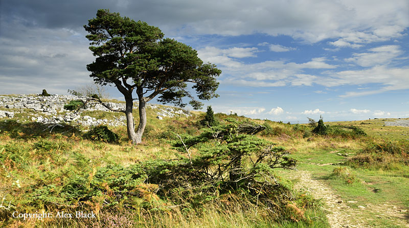
The Blawith Fells
This is a lovely area of fells sitting to the west of the southern end of Coniston Water. The area is clearly defined by a triangle of A-roads between Torver, Lowick and Broughton, with the quiet Woodland Valley lying down its western edge. Although slightly lower than the surrounding fells, they have a character all of their own, of rocky summits and hidden valleys, and a very attractive tarn; there is almost a feel of miniature mountains here. Wainwright covers the area in four walks.
Beacon Fell
Beacon Fell is the most northerly of the Blawith Fells, standing close to A5084, and at 255m, it is the highest point in the northern area of the group. Seen from the north, Beacon Fell has a distinctive peak, and although the summit is not as narrow as hoped, this is still a lovely miniature mountain. There is a mixture of rock and heather around the summit cairn, and it has the best view of Coniston Water from any summit in the group. Wainwright’s route starts from the lake-shore at Brown Howe, ascending the northern end of the fell; it then descends the southern end, then turns back north past Beacon Tarn. An alternative ascent can be made from the open area of common a little further south, visiting Beacon Tarn first. Curiously, although widely known as “Beacon Fell”, the name has not been adopted by the Ordnance Survey, instead the summit is simply marked as “Beacon” on the map.
Wool Knott
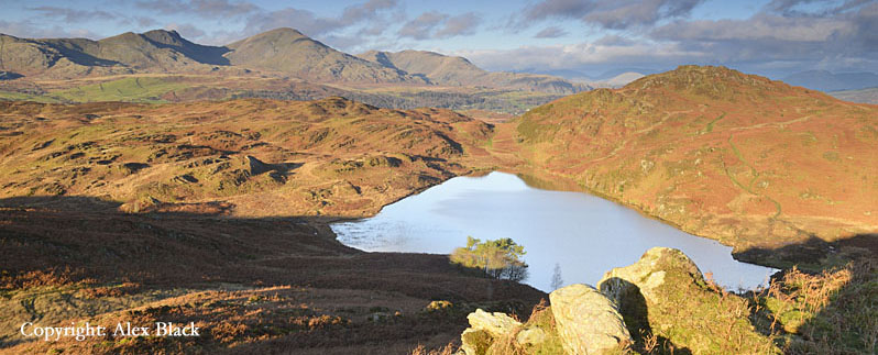
Wainwright calls the second of his four walks in this area The Woodland Fells, which covers an area just west of Beacon Fell. This is virtually a “horseshoe” route starting from the Woodland Valley, ascending by Yew Bank (207m) where there is an ancient cairn. The route then crosses a wide ridge of moorland to pass around the western side of Beacon Tarn, to then ascend Wool Knott (220m approx.) followed by the descent back to Woodland. Wool Knott is the highest point on the route, and lies about 1km south of Beacon Fell, with Beacon Tarn sitting between the two fells. It is also one of the nicest summits in the area and can be climbed separately from near the foot of Coniston Water. Beacon Tarn is a popular place to visit in its own right; there is a well-used path from Water Yeat leading up to the foot of the tarn, from where it is short walk up to Wool Knott’s distinctive double summit.
Blawith Knott
Blawith Knott is the next fell south of Wool Knott, which is a more rambling fell than either Beacon Fell or Wool Knott. The terrain here is far from being just rolling moorland with several little rocky summits and tarns, and as with everywhere on the Blawith Fells, the Coniston Fells dominate the views. At 248m, the summit is a similar height to Beacon Fell, and Wainwright’s walk includes the adjoining fell of Tottlebank Height (236m) which has a glimpse of Coniston Water.
Great Burney
Great Burney is the highest of the Blawith Fells (298m) and stands just inside the southern edge of the National Park, with high ground continuing south of the A5092 onto Kirkby Moor. There are a few crags here, but the fell provides a nice contrast as it is a much grassier fell than its neighbours. Its position so far to the south means it has a wide-ranging view across almost all of the high fells of the southern Lakes, including even the Scafells.
Walna Scar
Walna Scar is perhaps best-known as the ancient track from Coniston village to Seathwaite in the Duddon Valley, but it is also the name of a ridge just south of the top of the pass. At the height of 621m, Walna Scar is the highest fell in The Outlying Fells, and this is one of the longer walks in the book. The ridge includes three summits, the others being White Maiden and White Pike; although only a short distance away, White Pike is not visited on the Wainwright route. The Coniston Fells rise directly to the north of the top of Walna Scar Pass and unfortunately block a substantial part of the view, but there are great views across the Duddon Valley with a particularly good view of the Scafells from White Maiden.
Stickle Pike
There are many fine summits grouped around the Esk and Duddon valleys in the south-western quarter of Lakeland, and Stickle Pike is one of the best, although of modest height, just 375m. The two neighbouring fells are less distinctive, but equally rough: Great Stickle and Tarn Hill. Wainwright’s route starts at Broughton Mills in the Lickle Valley, then after visiting Stickle Pike, returns along a parallel ridge on the opposite side of Dunnerdale Beck (not to be confused with the Duddon Valley).
Great Worm Crag
The valleys of the Esk and the Duddon are separated by a long, wide ridge which finishes near the coast on Black Combe. This ridge has grand origins in the wilds of upper Eskdale, overlooked by Scafell Pike and Bow Fell. Wainwright covered the first three fells of this ridge in Book 4 of his Pictorial Guides, but did not go beyond Green Crag. Great Worm Crag is the next fell on the ridge, and is climbed from the Birker Fell road; for anyone wanting to extend their walk, it connects easily to Green Crag by a grassy ridge.
Whitfell and Buck Barrow
The ridge between Eskdale and the Duddon valley is crossed by three roads, the most southerly of these is the Corney Fell road; Black Combe lies to the south, but just north is a group of fells which are only slightly lower than their more-famous neighbour. Walking north from the top of the road these are three fells covered on this Wainwright walk: Buck Barrow (549m), Burn Moor (543m) and Whitfell (572m). Buck Barrow is probably the best summit here, having several rocky tops to visit, and is only about 1.2km from the road. Burn Moor is a wide and almost featureless stretch of moorland, but some rock returns at Whitfell, and being higher and further north, there is a clearer view of the fells around the head of Eskdale.
Black Combe
Black Combe is one of Lakeland’s most easily-identifiable fells; although the summit is a rather non-descript, flattish dome, it has the very respectable height of 600m; with the nearest fells of similar height being some 15kms away. Black Combe also occupies a prime position at the southern end of the wide ridge between the Esk and Duddon valleys, virtually rising from the sea on the south-western corner of the Lake District. Wainwright’s gives a choice of four routes in his chapter on Black Combe, which is unique in The Outlying Fells, but reflects the nature of the fell which sprawls across more than 6km east to west. The most-used route starts from Whicham Church at the southern end of the fell; this is a good path almost all the way to the top but peters out about 200m from the summit. There are in fact two tops, both wide and flat, and just 400m apart separated by a shallow dip. The northern top is the higher, and has the trig-point and a roughly circular wind-shelter; this is where the best views of the high fells are to be had, looking north-east to the Wasdale, Eskdale and Coniston Fells. The southern top is rockier and bears the main cairn, which overlooks the coast to the south and east, and is sometimes used as the site of a beacon.
Boat How (Eskdale)
Boat How stands on the northern side of Eskdale, and sits between the famous Wasdale Screes and the southern foothills of Scafell. The fell is mostly grassy moorland although the summit (337m) rises to a rocky knott, with Burnmoor Tarn about 800m to the north-east. Boat How would seem to be in a favoured position but neither The Screes nor Scafell are seen to their best; strictly speaking, The Screes are nowhere to be seen as it is the back of their parent fell, Illgill Head which occupies the view west. However, for many visitors here the main interest is the surprising number of ancient remains, including stone circles, to be found on the wide ridge of moorland, south-west of the summit.
Muncaster Fell
Muncaster Fell is a low ridge of about 4km, overlooking the Esk Estuary and Ravenglass at its western end. The summit, Hooker Crag (231m) is at the western end of the ridge with good views of Scafell and Eskdale
The fells mentioned here are less than half those covered by Wainwright in his book The Outlying Fells of Lakeland, but I hope to add more over the coming months.
Heughscar Hill
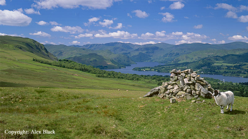
This low hill (375m approx.) rises to the south of Pooley Bridge at the foot of Ullswater, and with its gentle gradients it is an easy climb from there. The area around Heughscar Hill is one the richest areas for ancient remains in the Lake District. The High Street Roman road crosses the southern flank of the fell, and to the south and south-east, Heughscar Hill overlooks Moor Divock, a wide area of moorland where there are several ancient cairns, a stone circle (The Cockpit) and a standing stone (the Cop Stone). Wainwright starts his route at the attractive village of Askham to the east, which is a better starting-point to explore the antiquities of Moor Divock. But for most visitors to the fell it is the view of Ullswater from Heughscar Hill that will be the highlight, the lake snaking away towards the Helvellyn range.