Great Gable, Pillar and High Stile

This area of fells covers a wide sector of the Lake District between the Wasdale and Buttermere valleys, for which Wainwright list 33 fells. The area includes Ennerdale which effectively divides the fells into two groups, north and south; for both of these the highest ground is towards the eastern end where the ridges converge on the highest point of the Western Fells: Great Gable. At the western end of both groups the fells spread out and tend to become wide stretches of moorland or low, rolling hills.

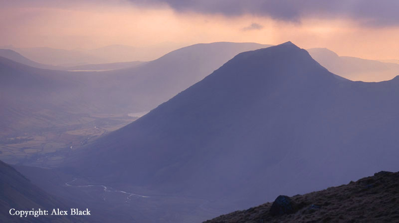
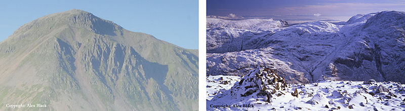
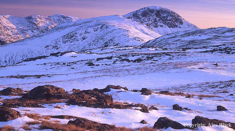
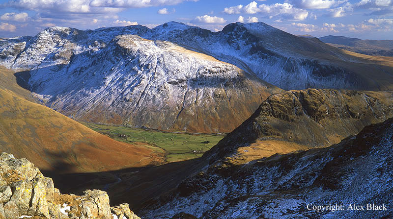
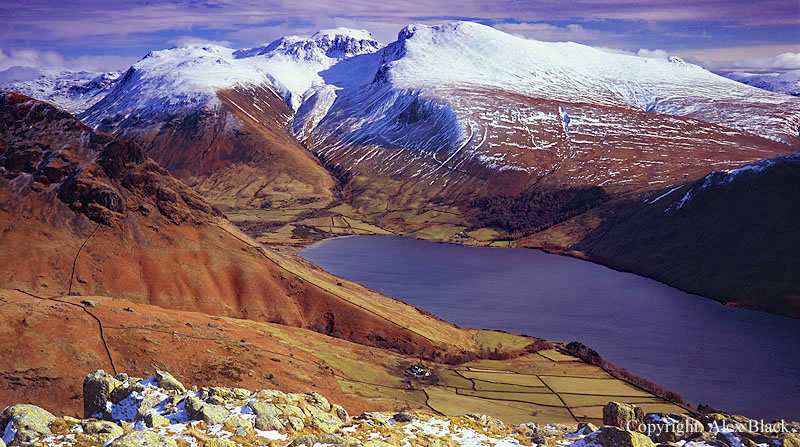
Great Gable (899m) is the highest of the Western Fells (England’s seventh highest mountain) and the hub of the Western Fells. It is arguably Lakelands most iconic mountain: in the famous view from Wast Water it has the classic, mountain form of a pyramid, albeit with a rounded summit, and for many years it has been one of Lakeland’s “must-do” fells. And Great Gable is not just for walkers, it has also been a magnet for rock climbers since the very earliest days of the sport. For climbers, their favoured crag has been the Great Napes which stands out from the screes on Gable’s south face.
However there are easy routes of ascent for walkers, the easiest is from Sty Head which can be reached from either Wasdale Head or Seathwaite in Borrowdale; from here a rough but simple path leads up to the summit.

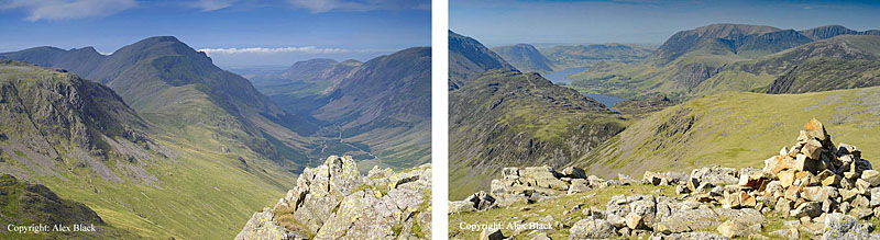
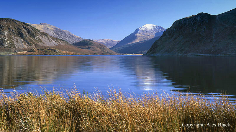
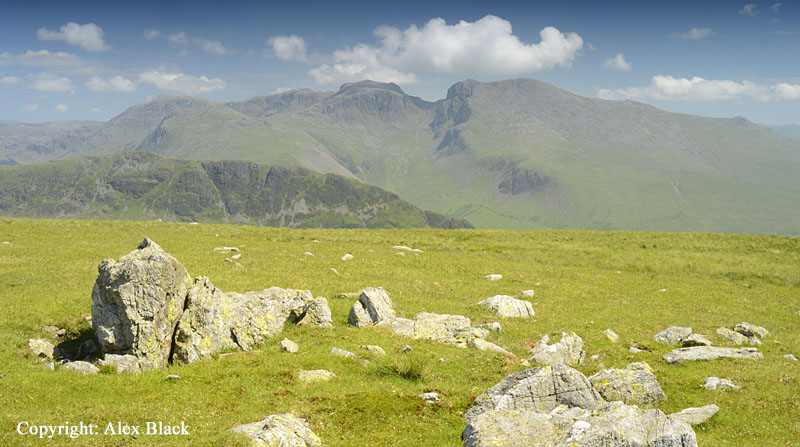
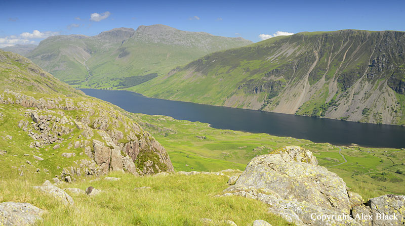
The view from the top of Great Gable is excellent, and is most famous for the view down on Wast Water; this is best seen from the Westmorland Cairn which stands on a rock platform 100m south-west of the summit. The view across the head of Wasdale to the Scafells is the other highlight, and there is a surprise glimpse of Windermere to the south-east.
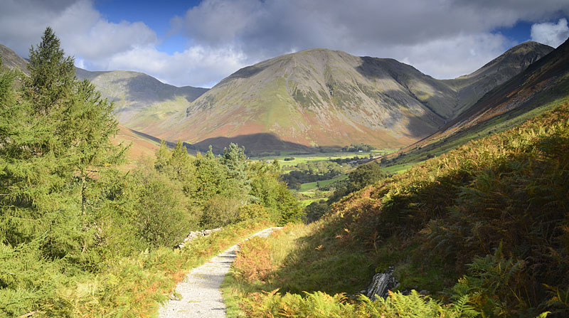
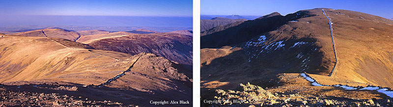
One of Lakeland’s best mountain walks is the ascent of Great Gable from the Honister Pass. This route starts off along one of the disused inclines from the quarrying, then turn left at the top of the hill. There is some marshy ground here but a good path soon appears which winds along the side of two fells: Grey Knotts (697m) and Brandreth (715m).
It is possible to leave the path and take in these summits, to get the views east, but one of the wonderful things about the path is the way the views open up to the west, first revealing Buttermere and Crummock Water then Ennerdale, then finally “the big reveal”: Wast Water from Great Gable.

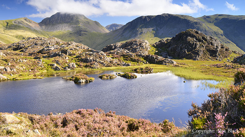
The route becomes a bit confusing on the western side of Brandreth; the higher, less-distinct path is the one needed to Gillercombe Head which is an area with small tarns. Just below here to the east is Base Brown (646m) which is an excellent but steep route up from Seathwaite. From Gillercombe Head the path makes a steady ascent of Green Gable (801m).
Green Gable is rather suck in the shadow of Great Gable but is still a good viewpoint in most directions, with a close-up view of Gable’s north crag. Heading on to Great Gable, there is a short descent to Windy Gap followed by a steep, rough ascent to the summit. Most guidebooks suggest leaving Great Gable’s summit heading north-east to Beck Head to follow the Moses’ Trod path back to Honister Pass.
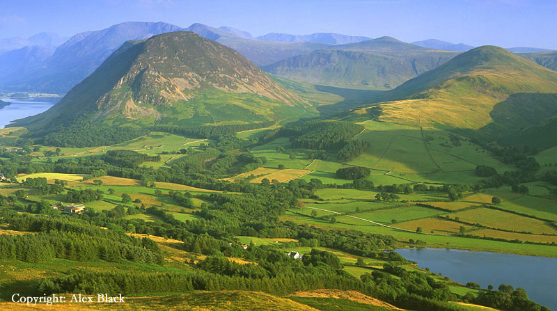
The other fell in this area which can be climbed easily from Honister Pass is Fleetwith Pike (648). It is probably better known from Buttermere from where it has a striking shape; the west ridge rises from the fields of Gatescarth in a dead straight line direct to the summit.
This ridge is probably the best route of ascent, the ascent from Honister being a bit of cheat, and far less interesting. Fleetwith Pike is sometimes called Honister Crag which is the fell’s main crag; this overlooks the western side of the Honister Pass road and was extensively quarried for slate.

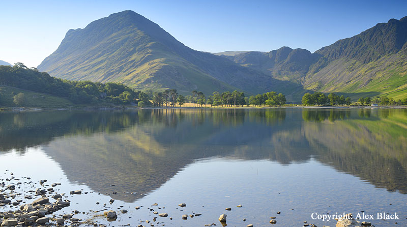
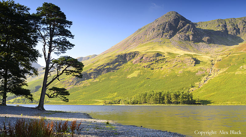
Perhaps Buttermere’s most famous fell is Haystacks (597m) which stands next to Fleetwith Pike at the south-east end of the lake. This was Wainwright’s favourite fell and his ashes were scattered on the summit near Innominate Tarn.
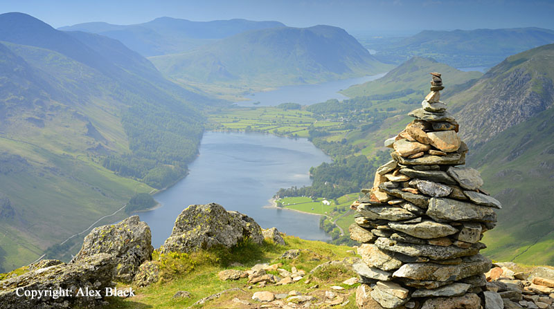
Haystacks is a wide ridge about 1.2km long, at its south-eastern end it connects with the slopes of Brandreth, so it can also be climbed from Honister Pass. This is a favourite walk, full of interest, particularly when the heather is out, passing a couple of tarns on the way: Blackbeck Tarn and Innominate Tarn.
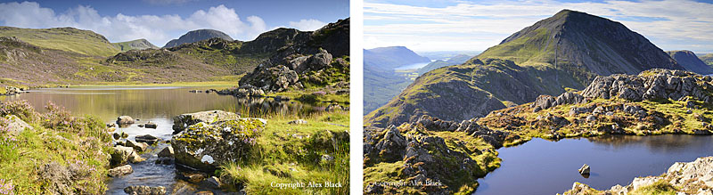
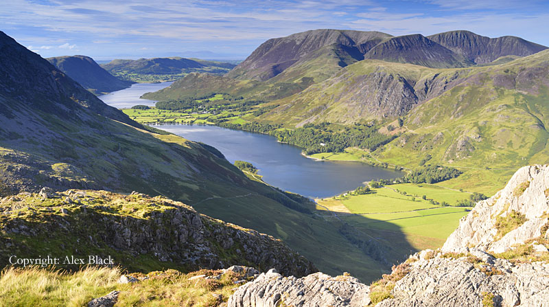
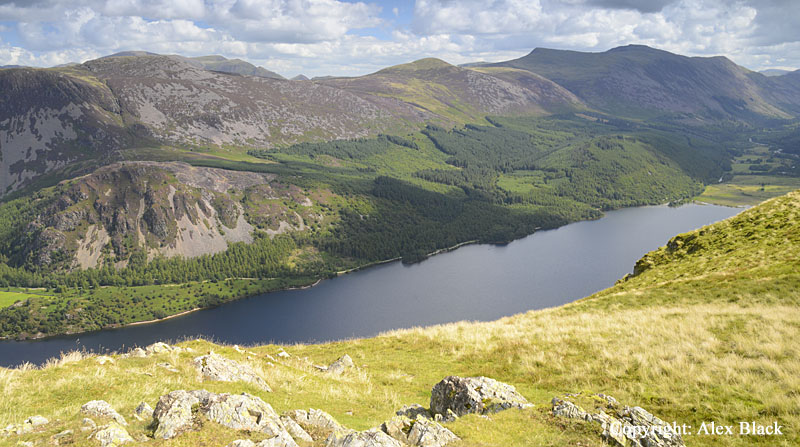
The summit is at the western end of its ridge, and in character with the rest of the fell, it is a mix of rocky outcrops and tarns. This is an excellent viewpoint, with views of Buttermere, Crummock Water and Ennerdale, with Great Gable also looking very impressive. The western end of Haystacks descends roughly to Scarth Gap which is a mountain pass connecting Buttermere with the upper valley of Ennerdale.
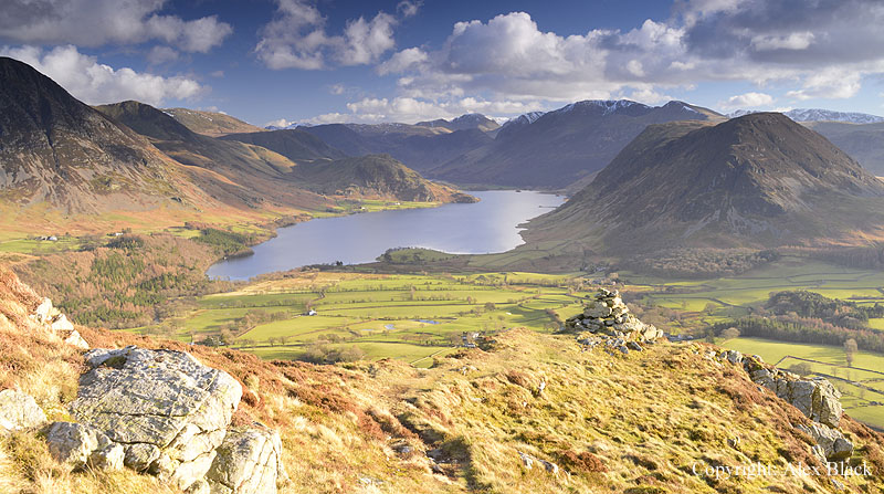
West of Scarth Gap the fells rise again to the High Stile ridge. This is a short, high ridge, about 2.5km (1.5 miles) long, which rises very steeply above the west shore of Buttermere. The ridge actually comprises of three Wainwright summits, from east to west they are High Crag, High Stile and Red Pike.
High Crag (744m) is probably the most attractive of the three when seen from Buttermere: a rough peak of grey rock rising steeply above the lake. Most walkers ascend (or descend) from Buttermere via Scarth Gap then up Gamiln End which is a steep scree slope. There is a rocky summit here with good views, but the best views are to be found on the highest and central peak on the ridge, the fell that gives its name to the ridge, High Stile.

From below, High Stile (807m) is perhaps the least attractive of the three, rising up steeply and roughly from Buttermere as a huge buttress with two coves either side; Wainwright gives a route of ascent up this ridge, but most walkers use the ridge from High Crag or Red Pike for High Stile, the direct ascent being relentlessly steep.

The highest point on the fell is at the top of this buttress. The summit is wider than expected, so a tour around its edges is needed to get the best of the views, which are wonderful in most directions; Great Gable standing at the head of Ennerdale is particularly impressive, with the Scafells behind.

Perhaps the best views are over Buttermere and Crummock Water, where the views sweep deeply down over the lakes. Just west of the summit is the top of Chapel Crags, a rocky buttress rising from Bleaberry Combe; this is the point which Wainwright takes as the summit of the fell, and from here there is a stunning view down to Bleaberry Tarn.
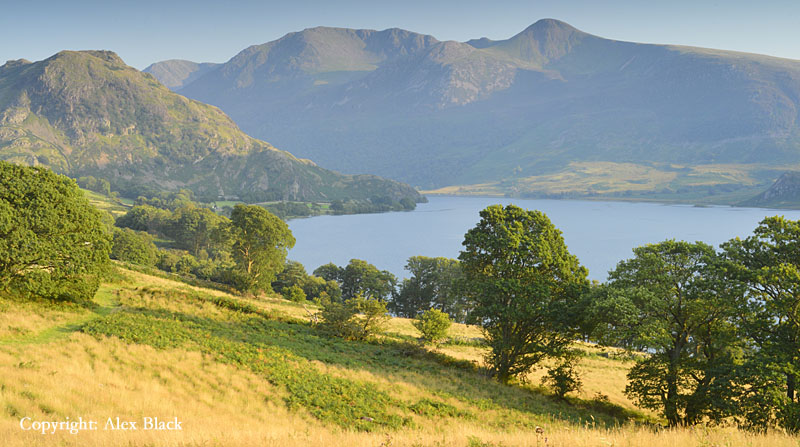
From Chapel Crags the ridge leads on to Red Pike (755m) which is probably the most attractive of the three fells. It is best seen from Crummock Water where it appears to sweep up from Buttermere over a lower summit, Dodd, to its domed peak which has distinctive red/brown screes falling directly below the summit. Such is its attraction that Red Pike is often climbed on its own, rather than as part of the ridge. Although High Stile, the higher fell, blocks views to the south-east, the views are almost as good here, with an excellent bird-eye view of Crummock Water. Red Pike has a privileged position with good views of many lakes; besides Crummock Water there are good views of Buttermere, Loweswater, Ennerdale and a surprise glimpse of Derwent Water.
West of Red Pike the ridge widens and becomes less rocky as it follows the north side of the Ennerdale valley. After about 2km it rises to the domed summit of Starling Dodd (633m). Although the best of the views have been left behind at Red Pike, there are unusual views of Crummock Water and Grasmoor, the head of the Ennerdale valley, and of Ennerdale Water itself.

Continuing west from Startling Dodd, an easy walk of about 2km brings you to the double summit of Great Bourne (616m). This is the last fell on the ridge, and rises steeply above the north shore of Ennerdale Water. The views are similar to those from Starling Dodd, with the best bit looking across Ennerdale to the craggy north sides of the Wasdale Fells.
North of the Great Bourne-Starling Dodd ridge and stretching to the shores of Crummock Water and Loweswater is a group of five fells known as the Loweswater Fells. On the whole, these are quiet fells of no great height and few crags, but there is a wonderful sense of wilderness here with views of the higher fells beyond. The highest of the five fells is Blake Fell (573m), but the most striking is Mellbreak.
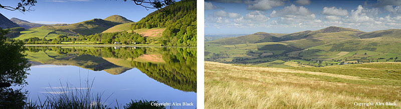
Rising steeply from the shores of Crummock Water is Mellbreak (512m). Few fells of moderate height have such a presence in the landscape, with its crags and distinctive shape drawing the eye from wherever it can be seen. Mellbreak is a favourite with many walkers, and is best climbed from the north, from Loweswater village. Although this northern end of Mellbreak appears rather fearsome, there is a popular path up through the crags and screes, which brings you to the fell’s north summit, which is the lower of Mellbreak’s two tops by just 4m. Cross the depression to the south summit, from where there are better views, particularly looking to Buttermere. Continue south, descending towards Scale Beck, from where there is a choice of routes back to Loweswater village. For the shorter route turn right and follow a path around the west side of Mellbreak through Mosedale. Alternatively, turn left to descend to Crummock Water, following the lakeshore path back north to Loweswater.
North of Loweswater and overlooking the Lorton Valley, Wainwright lists two more fells, Low Fell (423m) and Fellbarrow (416m). Despite being on the fringes of the Lake District and of modest height, Low Fell has become more popular recently, perhaps in recognition of its wonderful views over Crummock Water and up the Buttermere valley.

Fellbarrow has more the character of rolling hills: there are several tops, the highest having a trig-point.
Starting west from Great Gable is the other ridge which makes up the Western Fells, the first of which is Kirk Fell (802m). Although prominent in the skyline above Wasdale Head, Kirk Fell is often overlooked, perhaps by being rather bulky, but certainly lacking a distinctive summit. However, once on top, the summit is an attractive spot; there are two tops, the highest being almost above the south-west ridge, the other is about 400m to the north-east, with a small tarn between the two.
Kirk Fell’s height and position at the head of Wasdale almost guarantees it as an excellent viewpoint; the view of Great Gable is particularly impressive, as is the view of Wast Water.

At its north-western end, Kirk Fell connects with Pillar (892m). The name has been a source of curiosity and confusion over the years, but comes from the huge column of rock rising from the crags on its north face. This crag is now known as Pillar Rock, whereas the simple name “Pillar” has been adopted by the fell as a whole.
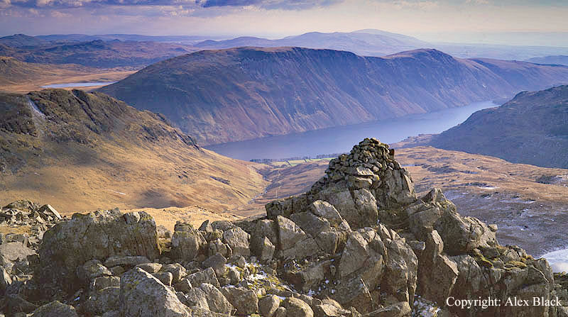
The simplest ascent is from Wasdale Head, starting along the path to Black Sail Pass; at the top of the pass turn left and a ridge takes you up in easy stages to the summit. For a more interesting ascent with views of Pillar Rock, follow this same route but turn off to the right on the first rise after Looking Stead, which is the little summit just above Black Sail Pass. This is the High Level Route which takes a line across the rugged north face of the fell, going past Pillar Rock; full details are of course in Wainwright’s book. The summit is rather disappointing being a stony plateau about 100m across, with the top marked by a trig-point. However there are excellent views of the fells, and Ennerdale Water is seen in full to the west.

Great Gable, Kirk Fell and Pillar all stand on the main ridge which divides Ennerdale from the Buttermere valley, and the next fell on this ridge is Scoat Fell (841m). This is the third highest of the Western Fells, but probably one of the least well-known as its long, flat summit makes it difficult to spot in views; its most distinguishing feature is the sharp peak on its north ridge, although this is such a prominent feature in its own right it is listed by Wainwright as a separate fell, Steeple (819m). Scoat Fell’s summit is typical of Lakeland’s higher fells, being flat and stony, its most remarkable feature is the substantial dry-stone wall running across it, east to west. There are excellent views in most directions, the two highlights are the views north and west of Steeple, and looking south-east over the deep valley of Mosedale to the Scafells.
Judged from a map, Steeple (819m) is little more than a rocky tor standing at the top of Scoat Fell’s north ridge, but when seen from almost any angle this is an arresting object worthy of the climb in itself. The route up from Ennerdale is excellent, with the ridge becoming rockier and narrower the higher you get. Nor does the summit disappoint, being small with the ground falling away sharply on most sides. Steeple is closely connected to its higher neighbour, Scoat Fell, by a short narrow ridge.
Scoat Fell stands at a cross-roads of ridges; north-west to Steeple, north-east to Pillar, to the south-west the main ridge continues, and to the south-east a rough walk of less than 1km takes you onto Red Pike (821m). Red Pike stands on the western side of Mosedale (a side valley north of Wasdale Head) rising steeply in a jumble of crags and rocks.
There are easier gradients on the western side, but this side of the fell is just as wild, with two small tarns hidden away in rocky hollows here. The summit is a ridge with several cairns marking good viewpoints, the highest point is perched on the edge of the escarpment overlooking Mosedale.
The south end of Red Pike widens and descends to Dore Head where it links to Yewbarrow (627m). Yewbarrow has a striking appearance when seen from the west end of Wast Water, from here it has the shape of a steep-sided pyramid, complementing Great Gable in the classic view. However, this is just seeing the fell end-on as Yewbarrow is in fact a ridge all of its own, the summit of which is about 1.5km long. But this should not detract from the fell which is a difficult ascent; both of the natural lines of approach are steep and rough, with the only easy route being to slant up from near Dore Head. The summit gives good views of the fells around Wasdale Head, although this is better seen from the north top above Dore Head (Stirrup Crag) and similarly, the view of Wast Water is also better seen from the south end of the ridge.
Following the main ridge west from Scoat Fell, the next fell is Haycock (797m). In most views this appears as a large, grassy dome with a lower, craggy top to the west. There are crags on the north side of Haycock, but really, the best of the rock-scenery is east of here.
Looking west there is a wide view of rolling moorland, gradually descending to the towns and fields of the West Cumbrian coast. More interesting are the views east to the Lakeland’s high fells, and a glimpse of Wast Water to the south-east.

The last high fell listed by Wainwight on the east-west ridge from Great Gable is Caw Fell (695m approx.) just 1.4km west of Haycock. This in many ways feels like the edge of Lakeland, there is still rocky ground here, but a little further west the fells become rolling moorland stretching for several miles.

North from Caw Fell, a high, wide ridge stretches north-west towards the foot of Ennerdale Water. This is Iron Crag (640m) which on the map appears to be a significant fell; however, in spite of its height and size it is not listed by Wainwright as a separate fell, and on closer acquaintance it turns out to be a rather dreary place. But Iron Crag links in with three other fells: Crag Fell, Grike and Lank Rigg.
Crag Fell (523m) is without doubt the best of these, with the summit perched above the foot of Ennerdale Water. This side of the fell is its best feature, with Angler’s Crag being a famous obstacle on the lakeshore path. The summit has a bird’s-eye view over the lake, and is one of the best place to survey the fells around the head of Ennerdale.
Just over 1km west of Crag Fell is Grike (488m); this is a pleasant, grassy summit but the best of the views are from Crag Fell.
About 2km south of Grike is Lank Rigg (541m). This fell stands isolated from its neighbours amid a wide (and wild) stretch of moorland. There are very few interesting features here, and with such disappointing views that even Wainwright seemed to doubt whether anyone would think Lank Rigg worth visiting.
South of Haycock is a group of three fells which overlook the west end of Wast Water, the first is Middle Fell (582m). If it were situated anywhere else, this rugged fell would be a popular climb, but with so many famous peaks nearby it is usually overlooked. Middle Fell is so rough there is only really one route of ascent which is from Greendale, a tiny hamlet on the road to Gosforth. This approaches the summit from the west and has the advantage of revealing the excellent view of Wast Water at the last minute.
Heading north from Middle Fell, paths lead north onto the wide, flat summit of Seatallan (692m). The views here are rather limited, but there is still an excellent view of the Scafells. From here it is possible to continue onto Haycock (3km to the north) but bearing south-west completes a nice little horseshoe route to Buckbarrow.
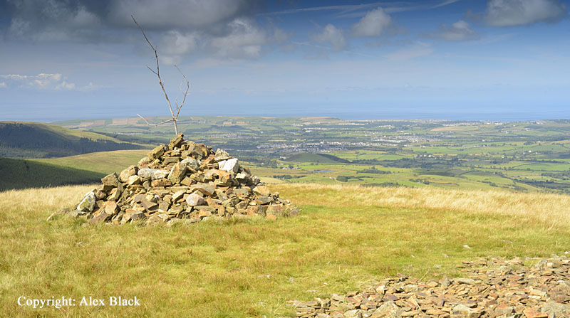
Buckbarrow (400m approx.) is really just a crag at the south end of Seatallan, but it is such an attractive and conspicuous object in the skyline around Wast Water it has earnt itself a separate chapter in Wainwright. A short, steep ascent from the road by the side of Gill Beck brings you to the top of the crag; there is no obvious summit, but this will not matter much as there is such a good view of Wast Water and The Screes.