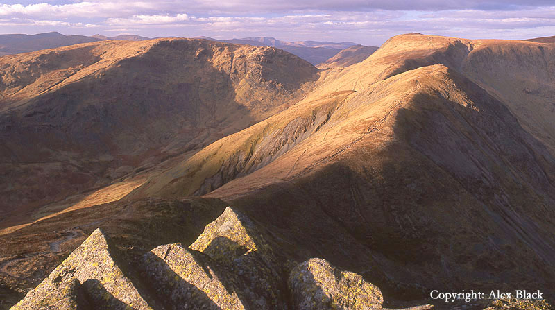
Walking The Wainwrights
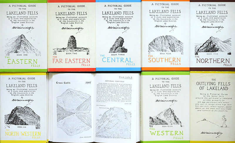
For anyone who doesn’t know, The Wainwrights is a list of 214 fells in the Lake District which was drawn up by Alfred Wainwright in the 1950s. From 1955 to 1966 he published a series of 7 beautifully-produced, pocket-sized guidebooks, all hand-written with his own pen and ink maps and illustrations. These are the “Pictorial Guides to the Lakeland Fells”. They may now perhaps look a little old-fashioned, but they have rarely been equalled for their detail and the number of routes covered for each fell. Since their first publication, they have hardly ever been out-of-print, and have been recently revised and checked to make sure the routes are still accurate and useable.
Over the following years, Wainwright published many other books including a series of sketchbooks for the Lake District and the Scottish Highlands; there were also the Pennine Way Companion and walking guides for the Limestone Dales and Howgill Fells of the Yorkshire Dales. Perhaps his other most famous book was the Coast to Coast Path (1973), a route across the north of England linking three National Parks, still one of the most popular long-distance routes walked today.
Almost 10 years after publishing the “Pictorial Guides…” there was a follow-up book: “The Outlying Fells of Lakeland”; this covers 56 hills and routes which fell outside his original series, often lower in height to the higher fells of the central Lakes, but still full of interest. For the true Wainwright devotee, this brings to a total of 270 Lakeland Fells to do, not quite as many as the Scottish Munros, but still enough of a challenge.
The one thing that is often mentioned rather dismissively is that “doing The Wainwrights” is just a tedious, box-ticking exercise. But of course, there are various way of doing The Wainwrights, and I doubt whether there are many people slavishly following the list, rushing from one hill to the next, simply “peak bagging” the summits as the awful phrase goes. My excuse is that for those of us who love The Lakes and live here or visit often, the “Pictorial Guides…” are simply a wonderful way of exploring the hills and getting you off the beaten path, getting you out to new places you would never think of visiting, or finding views you never thought existed.
For anyone interested in reading my own story of “Doing The Wainwrights”, please read on below, but for anyone simply interested in seeing the landscape of the Lakeland Fells, or getting a bit of inspiration for walks and views, please use the links in the menu bar above or the links below. This is how the links work, and how Wainwright set out his original 7 books and their sequel:
Book 1, The Eastern Fells: Helvellyn and Fairfield. Covering the fells between Grasmere, Thirlmere, Ullswater, Patterdale and Ambleside: http://alexblacklandscape.co.uk/book-1-the-eastern-fells/
Book 2, The Far Eastern Fells: High Street. Covering the fells east of Ullswater and Ambleside: http://alexblacklandscape.co.uk/book-2-the-far-eastern-fells/
Book 3, The Central Fells High Raise: Ullscarf and the Langdale Pikes. Covering the fells north of Ambleside to Keswick, between Grasmere and Thirlmere in the east, to Langdale and Borrowdale in the west: http://alexblacklandscape.co.uk/book-3-the-central-fells/
Book 4, The Southern Fells: Scafell and Scafell Pike, Bow Fell and the Coniston Fells. Covering the fells between Coniston and Langdale in the east, and Eskdale and Wasdale in the west: http://alexblacklandscape.co.uk/book-4-the-southern-fells/
Book 5, The Northern Fells: Skiddaw and Blencathra. Covering the fells north of Keswick and Threlkeld, up to Uldale, Caldbeck and Heskett Newmarket: http://alexblacklandscape.co.uk/book-5-the-northern-fells/
Book 6, The North Eastern Fells: Grasmoor and Grisedale Pike. Covering the fells west of Derwent Water and Borrowdale to Buttermere, Crummock Water and the Lorton Valley: http://alexblacklandscape.co.uk/book-5-the-north-western-fells/
Book 7, The Western Fells: Great Gable and Pillar. Covering the fells north of Wasdale and south of Buttermere, Crummock Water and the Lorton Valley: http://alexblacklandscape.co.uk/book-7-the-western-fells/
The Outlying Fells (Book 8): Black Combe and many others. This book covers 56 fells and routes, not included in the original series; they are scattered around the edges of the Lake District, but are within the National Park
These pages are now all ready to view except for The Outlying Fells which I hope to have ready soon. However I will continue to add photos to all these pages, so please check back in to see new views.
For more information about Wainwright, the man and his books, the Wainwright Society has a web-site worth visiting: http://www.wainwright.org.uk
Doing the Wainwrights: my own story
In May 2018 I finally visited my last “Wainwright”. I say finally because it had taken me almost 30 years to visit the summits of all 214 fells listed by Wainwright. These days it almost feels like they should be “bagged” as quickly as possible; one runner has recently covered the 318miles (511km) in a little over six days and six hours. While I appreciate the physical achievement of this (and must admit to being a little jealous too) I feel I should put in a word for what might be called “slow bagging” as a better way to appreciate the Lakeland Fells.

My own first Wainwright was Helvellyn which I visited during a family holiday in the summer of 1989. We were amazingly lucky with the weather, day after day of glorious sunshine, and it was almost as an afterthought that we decided to climb one of the hills we had been looking at. We had been using The Good Guide to the Lakes by Hunter Davis, and following his advice, we went up Helvellyn from Swirls. Before we set off, I had been more interested in walking down to explore Thirlmere’s lakeshore, but decided to tag along with the others; my first Wainwright therefore seems to have been something that happened by chance. I cannot remember feeling hooked by the experience, but a day or two later we decided to go up Skiddaw via Dodd Wood, although we turned back at Carl Side as we were put off by the look of the screes on the last mile up to the summit. But something must have impressed me about the Lake District because, in just under a year, I was living in Grasmere.
Grasmere is of course a lovely spot and an excellent place to start exploring the fells, but although I spent a lot of my spare time walking, I did not suddenly start bagging fells. However, I had already heard of Wainwright through the original TV series with Eric Robson in the mid-1980s. I must confess, I actually thought him rather ridiculous at the time, talking of the hills as being “my old friends”, but somehow, subconsciously, I must have been hooked. Wainwright died in 1991 and shortly afterwards it was announced that the original, local publishers (the Westmorland Gazette in Kendal) would be handing over to a national publishers and it was feared that the distinctive look and feel of his books would be lost – I dashed out and bought the full set of the Pictorial Guides.
But even then, with a full set of the Wainwright guides (including the Outlying Fells volume), I was not rushing around to tick off a list. It has almost always been more important for me to visit places I find interesting although there have been times when I have made a bit more effort to visit a hill or group of hills I had so far missed out – “you don’t know if you don’t go” as they say. I was using the books in the way Wainwright almost certainly intended, as guidebooks. At this time I did not have a car, but Grasmere is a great place to walk from, with many favourite hills overlooking the lake: on the western side there are some lovely lower fells: Loughrigg, Silver How, Helm Crag and the Greenburn Horseshoe, and rising on the eastern side is Fairfield and its Horseshoe; Helvellyn is also possible from Grasmere.

Being young and fit, I was able to do some massive walks in those days: I managed to walk from Grasmere to Scafell Pike and back on three occasions (going via Bow Fell), Grasmere to Great Gable and back, and the Coniston Fells and back, visiting all 7 summits over 2500ft, all in one long day. The bus service was also pretty useful, particularly for getting up to the fells around Keswick.

One of the really big walks I did started by catching the bus south to Troutbeck Bridge and walking up to the Garburn Pass, over Ill Bell and Thornthwaite Crag to High Street. But I did not stop there; I carried on north and did a quick circuit of the three summits north of the Straights of Riggindale, then down past Angle Tarn to Patterdale, walking back to Grasmere over the Grisedale Hause.

For me, this was still not about peak-bagging. Although I would have visited 8 new summits that day, it was still more about exploring and getting to places I wanted to visit. One of my targets for that day was Ill Bell; I had seen it in the distance for many years, its neat conical summit and connecting ridges had always appealed to me: it was asking to be climbed, and from there it was not too far onto High Street, the highest point east of Ullswater, and from there, why not carry on rather than turn back…?
In 1993 I decided to take my landscape photography more seriously and bought a medium format camera, and since then the photography has generally been the priority. The following year I got a car, and at about the same time I put a Wainwright Fells list up on a wall, with some vague plan about visiting all the fells and photographing them. Perhaps this sounds suspiciously like peak-bagging, but looking through some old photos recently, I noticed that I was on Helvellyn and the Dodds almost every possible day, rather than dashing off to new hills; so still not just obsessed with just ticking off summits.
Over the next 10-15 years I steadily visited most of the Lakeland fells, including many of my favourite fells and some of the Outlying Fells too, usually with the idea of exploring and finding new walks or finding a new view to photograph. In 1997 I passed a bit of a landmark, having visited all the summits over 2000ft, but I was still visiting other areas such as the Howgills and Yorkshire Dales: so still definitely not dashing from summit to Lakeland summit.
By 2008 I had about a dozen fells still to visit and it was probably only at this time that I made something of a concerted effort to finish off the list. Most of the fells left were on the western fringes of the Lake District near Ennerdale and Loweswater. These were in a couple of clusters and the summits are easy to visit within a couple of well-planned days: even so, there was no rush, and my photography came first, so it still took me a couple of years to get them ticked off.
But for almost 10 years one hill still remained: The Nab.

I believe I was not alone in leaving The Nab until last. The Nab stands in one of Lakeland’s more out-of-the-way places, standing in Martindale amongst the northern High Street fells; not one of the obvious places to set off into the hills. But perhaps more importantly, walking routes to The Nab were then rather uncertain; being within the Martindale Deer Forest it was, strictly speaking, private property with no legal right of access. This was a unique situation within the Lake District where access to the higher fells has been taken for granted for hundreds of years. But still, The Nab was a “Wainwright” and could not, should not be missed! In his guide book Wainwright suggested a couple of routes up from Martindale, but with the caveat that walkers would need to get permission from the landowner. Alternatively, it had generally been assumed by walkers that it was acceptable to visit the summit by dropping down onto the fell from Rest Dodd, the higher, connecting fell. This ridge route was included in Wainwright, with cautionary notes about permissions: I had passed this way many times before but was never quite convinced about this assumed route of access, so had never attempted it.
Besides the legalities, there was another big problem with this route: the “ridge” was pretty unappealing due to a long, wide area of peat bog; not much fun to cross except in wellies. But then in 2000 one of the hurdles was lifted when the Right to Roam act was introduced and access to The Nab was legally granted, hoorah! After 2000 I walked past the The Nab at least twice with the clear intention of bagging it from Rest Dodd, but somehow the higher fells on the main ridge of High Street always seemed much more attractive, so I walked on past even though it was now my last Wainwright left to bag!
In 2018, I finally put the record straight. A year or two before I had mentioned to my boss that I had done all the Wainwrights except one, and although he was not such a keen fell-walker, this omission amused him. The year 2018 will long be remembered as one of the best summers on record, and I happened to mention to my boss that I was almost running out of things to do; he of course said “Why not do The Nab?” It was only then that the penny dropped: with the drought, the route across the peat bog could easily be crossed, so the next day I did it.
After about 30 years I had finally visited the 214 Wainwrights, and I think that is the right way to do it. It is great to get them all done and I can definitely recommend it as a way to see the whole of the Lake District. But there’s no rush. If you have a favourite fell, go there again and again; I can recommend going at different times of the year, and Wainwright usually gives a choice of routes to try. And if you manage to get through the 214, there are still the Outlying Fells to do.